COGO ENGINEERING AND MAPPING SURVEYORS

✻ Survey precisely
✻ Acquire land fairly
✻ Build with confidence

Precise surveys for land, infrastructure and the people who depend on them

COGO delivers engineering, cadastral and mapping surveys, land acquisition and valuation across Uganda and East Africa, on time and at a fair cost.

About COGO

COGO Engineering and Mapping Surveyors is a registered Ugandan firm that solves land and positioning challenges for communities, governments, engineers and architects, from registering land rights to setting out the structures that change a region.

The team

A motivated, experienced team that supports clients from identification and formulation to implementation, monitoring and evaluation.

Our uniqueness

We embrace new technology in the field and put stakeholder engagement first on every project.

On time, on budget

We invest time upfront to understand your needs, then manage delivery to your timeline and budget.

Project delivery

Major projects delivered

0 +
Our people

Surveyors, valuers and sociologists

0 +
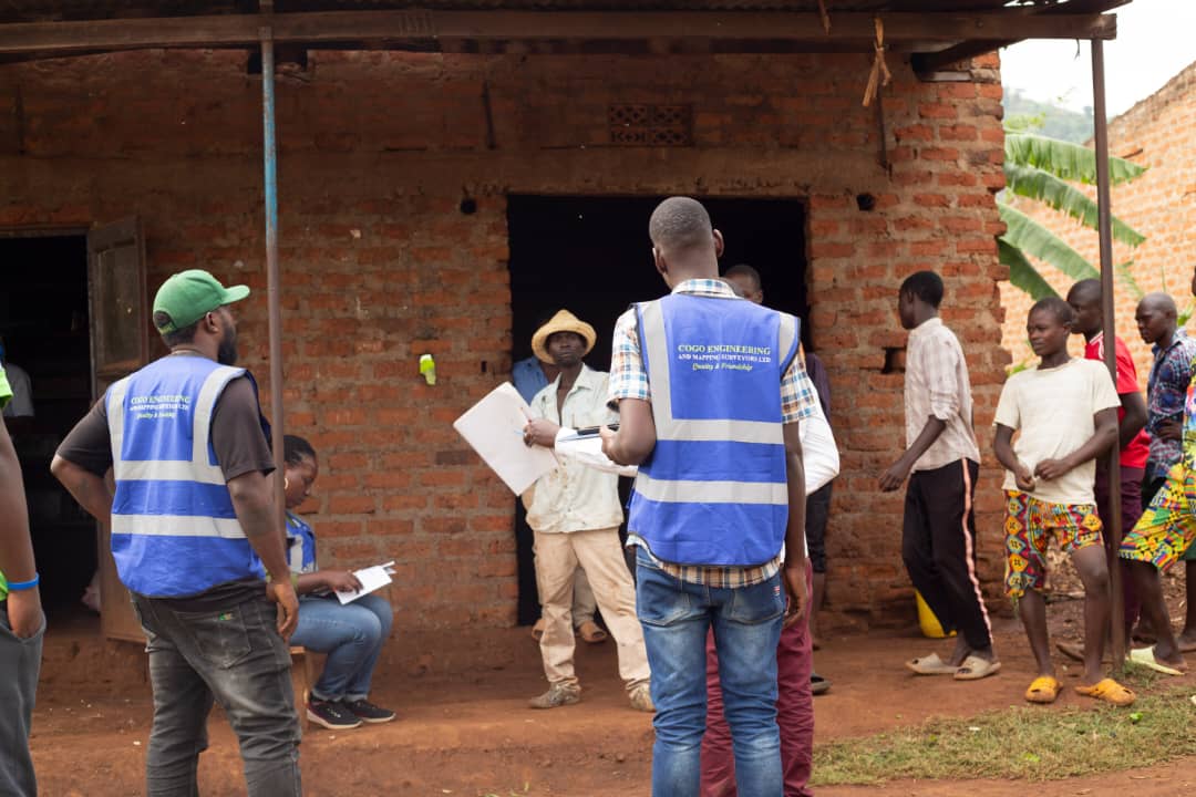
Field team group photo hi-vis 1 — COGO field photo

“The success of any consulting assignment depends on the team assembled to do the work, and on the qualifications and ability of every person on it.”

— The COGO Team

Engineering & Mapping Surveyors

Clients & partners we have worked with

We have delivered for 19+ clients, consultants and public agencies

Client logo
Client logo
Client logo
Armstrong logo
Government of Uganda logo
Mota-Engil logo
Nile Heavy Engineering logo
Queensland and Leads Consulting Engineers logo
TATS Technical Services logo
World Bank logo
JBN Consults and Planners logo
Uganda National Roads Authority logo
SMEC logo
FBW logo
Dott Services logo
JBN Consults logo
KEA Group logo
SMEC logo
Tysult Engineers logo
What we do

Seven survey disciplines. One accountable team.

Feasibility and topographic surveys

RoadsWaterlinesPowerlinesDamsBuildingsRailwaysMining sitesOil & gasAgriculture

Topographic surveys to the level of plans, profiles and contours, as required by international standards for public and private investments.

Land acquisition (Resettlement Action Plan)

RAP preparationRAP implementationEvaluation & monitoringCompletion auditsInfrastructureLandfillsQuarries

We support clients and governments across East Africa to prepare, implement, monitor and audit Resettlement Action Plans.

Property valuation

Buying & sellingMortgagesInsuranceCompensationLand & buildings

Property valuation when buying and selling, mortgaging, and for other purposes including insurance.

Hydrographic surveys (bathymetry)

RiversLakesBathymetryProfilesHydropowerWater supply

Bathymetric surveys on rivers and lakes, with production of profiles.

Setting out, earthworks and structural monitoring

Setting outEarthwork volumesStructural monitoringAs-built surveys

Setting out of structures, earthwork survey and volume calculation, structural monitoring and as-built surveys.

Survey control extension and deformation monitoring

Horizontal controlVertical controlDensificationDeformation monitoringAerial triangulation

Establishment and densification of horizontal and vertical control, monitoring, and ground control for aerial triangulation.

Cadastre and real estate management

Boundary openingSubdivisionTitle registrationTitle transferPlot locationTown planning

Real estate planning, boundary opening, land acquisition, subdivision, title registration and transfer, and plot location surveys.

Sectors we serve

Every project that builds on land needs a precise survey.

Our projects

See what happens when careful fieldwork meets clear delivery.

How we work

Inception & engagement

We meet you, study the terms of reference and brief district officials and local leaders before any team goes to the field.

Terms of reference reviewCourtesy calls to districtsStakeholder mappingWork plan & schedule

Field data collection

Survey teams establish control and capture topography, boundaries, assets and household data with modern instruments.

Survey controlTopographic pick-upCadastral surveysCensus & asset inventory

Processing, GIS & design

Data is checked, processed and managed in GIS to produce models, maps, route designs and valuations.

Quality checksGIS data managementPlans & profilesValuation

Reporting & handover

We present findings, deliver reports and stay available for monitoring, audits and follow-up questions.

Draft & final reportsClient presentationsMonitoring & auditsOngoing support

A clear process from first meeting to final plan.

In the field
Since 2020
✦ ✦ ✦ ✦ ✦
Serving clients across Uganda

We believe in open participation from landowners to funders and end users. An assignment succeeds when its purpose is achieved, embraced and owned by everyone involved.

COGO compass and surveyor emblem
COGO Engineering & Mapping Surveyors
Kireka, Kampala
Why choose us

Guesswork on land costs more. Here is the difference.

Without a precise survey

With COGO

Frequently asked questions

Questions people ask before working with us

Straight answers to the questions clients ask before a survey starts.

A land surveying company in Uganda such as COGO provides topographic surveys, cadastral (boundary and title) surveys, Resettlement Action Plan (RAP) consultancy, property valuation, hydrographic surveys, setting out and structural monitoring, and survey control extension for public and private sector projects.
Land survey costs in Uganda vary based on plot size, terrain, location and survey type (boundary, topographic, cadastral, etc.). Simple boundary surveys can start from a few hundred thousand Ugandan shillings, while large infrastructure or feasibility surveys are quoted per project. Contact COGO for a free, no-obligation quote tailored to your project.
A Resettlement Action Plan (RAP) is a document required for infrastructure, energy and road projects in Uganda that involve land acquisition or displacement of people. It is typically mandated by government agencies and development partners such as the World Bank, AfDB and JICA. COGO prepares, implements, monitors and audits RAPs for projects across Uganda and East Africa.
Timelines depend on plot size, site accessibility and survey scope. A single plot boundary survey can often be completed within a few days, while large topographic surveys for roads, powerlines or dams may take several weeks. COGO provides a project timeline upfront after an initial site assessment.
Yes. COGO Engineering and Mapping Surveyors Ltd is a registered surveying firm based in Kampala, Uganda, and its professional staff are members of the Institution of Surveyors of Uganda (ISU).
COGO is based in Kireka, Kampala, and carries out land surveying, RAP and engineering survey projects across Uganda, including Eastern, Northern and Western regions, as well as regional projects in East Africa.